Relic point Vietnam
Việt Nam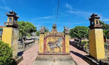
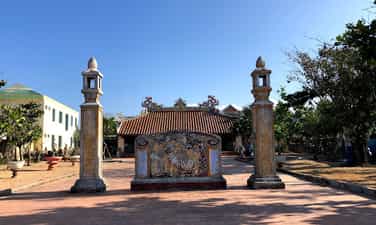
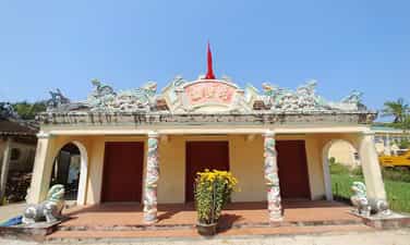
Ong Pagoda
Ong Pagoda (Quan Thanh Tu) is located in the town of Tu Thu Xa, Nghia Hoa commune, Tu Nghia district, 10km from Quang Ngai city to the east. The pagoda was made by 4 states of Hoa Minh Huong (Fujian, Trieu Chau, Hainan, Guangdong) living in Thu Xa Kien area in the second Minh Mang year (1821) and has undergone 4 restoration in 1881, 1894, 1920, 1991. Ong Pagoda worships Quan Vu in the main hall, worshiping Avalokitesvara Bodhisattva (people of China and Vietnam called Buddha Quan Am Nam Hai) in the harem space in the model of "Money Holy Buddha". In addition, the harem also worshiped Thien Hau, Kim Dau and 12 midwives. In terms of scale, although Ong Pagoda seems humble compared to the temples worshiping Quan Cong in Hoi An (Quang Nam), there is a harmonious combination of flower -Vietnamese architectural elements in a whole rich aesthetic. According to the profile of the General Museum of Quang Ngai province, the pagoda has a total area of 2,730m2, including temple garden, Tam Quan, pagoda yard and pagoda. All are surrounded by round 1, 1.2m high, 0.5m thick in a parallel style. The pagoda turned to the east. From the outside, the architectural works are arranged on a trary axis, tightly layout, posted in sequentially including: Tam Quan, Binh Phong - Tieu Tieu, Trong - Bell floor and temple. On both sides of the facade, there are two low gates, behind the temple is the temple to worship Tieu Dien Sy. Tam Quan gate structured one space, four columns, two sets because of the anti -fruit, in the way of the diaphragm. The third diaphragm bends the shape of the boat decorated with the head of the phoenix tail. The diaphragm is linked through the husbands and gloking through the column head. The roof of the tam tile roofed with yin and yang tiles, the top of the boat bent the boat, decorated the dragon shape, the tail covered with vegetable vines. The roof is decorated in the form of a box with five decorative cells. The two sides of the three gate are the temple of Ba Thien Hau. Battan Phong 2m high, with three compounds, the front covered with tiger shaped tiger bared the tail to look very vivid, the back covered the shape of the glass on the roof cluster. On both sides of Binh Phong are two pillars. Bell floors, drum floor built posted through the axis. Ong Pagoda currently holds 6 steles, epitaphs of Han characters, created in 1895 (7th Thai Thanh), 1920 (5th Khai Dinh), which are the years when the temple restores. Decorative stone stele touches the dragon painting in the forehead, the brazen beer is decorated with the dragon's head wrapped in a vegetable vine. The epitaph records the list of people who worship the money, including the name of the person, the place of residence, and the amount of money. In general, the art of decoration at Ong Dat Pagoda is quite sophisticated, especially the technique of embossing, touching, puncturing, touching on the screen, wooden walls, worshiping, trap, pattern, husband, statue, briefcase ... Ong pagoda has a harmonious combination of architectural elements of Vietnamese and Chinese people. In addition to the main components and materials of the traditional communal house in the Central region (the baseballs' husbands, the fake husband's husband) also has the appearance of the hiding of the planet of the Northern Delta and the set of the pumpkin husband's style of the North China style. Ong Pagoda was recognized by the Ministry of Culture and Sports (now the Ministry of Culture, Sports and Tourism) to recognize the national monument under Decision No. 43 of the Culture/Decision on January 7, 1993. Source of Quang Ngai Electronic Information Portal.
Quang Ngai
3378 view
Rating : National relics.
Truong Dinh Temple
Truong Dinh Hero is a famous hero in Vietnamese history in the fight against the French colonialists in the period from 1859 to 1864. Truong Dinh was born in Tu Cung village, Quang Ngai province. He followed his father to the South and established Tan An and Dinh Tuong. Truong Dinh led the army to raid the French plantation after the French army attacked Gia Dinh in 1859. However, when the court signed the Nham Tuat Peace Contract in 1862, yielding to three Eastern provinces to France, Truong Dinh Dinh Do not accept the beach and take office in An Giang as the court's order. Instead, he continued the war with the title of Binh Tay Dai Marshal, with the support of the people and the Confucianists. His fight against French was shocked with many illustrious feats. However, on August 19, 1864, in the dark leaves in Go Cong Dong, Truong Dinh was seriously injured. In order to preserve the honor, he decided to commit suicide at Pond Dinh, Go Cong, causing his people and soldiers to be heartbroken and regretful. After Truong Dinh died, King Tu Duc awarded the title and built a temple in Tu Cung village, Quang Ngai to commemorate him. Truong Dinh Temple, currently located in Khe Thuan hamlet, Tinh Khe commune, Quang Ngai city, Quang Ngai province, is the place to worship the national hero Truong Dinh. The temple was ranked by the People's Committee of Quang Ngai province in 2014, and recognized as a national historical monument on February 24, 2023. Source of Quang Ngai Electronic Information Portal.
Quang Ngai
3618 view
Rating : National relics.
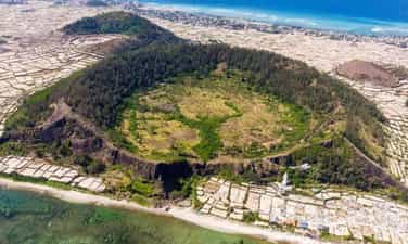
Gieng Tien mountain relics
Gieng Tien and Thoi Loi volcano are two unique mountains in Ly Son Island, Quang Ngai, belonging to the group of 10 volcanoes discovered in this area. Gieng Mien volcano, 86m high, has hundreds of meters wide, covered with fertile red soil and green all year round. At the foot of the mountain is Chocolate Pagoda, with the statue of Quan The Am 27m high, considered to protect fishermen at sea. Standing from the top of Gieng Tien Mountain, you can see the panoramic view of Ly Son Island and see the baby island in the middle of the sea. Gieng Tien Mountain, also known by the locals, is located in the territory of Tay village, An Vinh commune, Ly Son island district, Quang Ngai and is the second largest volcano on the island. This volcano has a height of 90m, an area of about 0.45 km2 and the diameter of the operating range is 500m. This volcano has a very round and pointed mouth shape, like the image of a coin, also because of this special shape that the locals have named the Gieng Tien mountain. Gieng Tien Mountain also has geological characteristics similar to Thoi Loi volcano, when undergoing erosion, creating stone walls, which the people used to create steps to lead to the crater. Gieng Mount Mountain was formed from a prehistoric period of about 3,000 to 4000 years ago. Therefore, this mountain has witnessed extremely prominent events of the geological formation process on the island. Since then, the landscape and geology here are also very special, this place has each layer of ashes falling into the debris that has accumulated when volcanoes operate on the slope of the volcano and almost no ruins of Sea ink on the cliffs. Because of the geological creation over time, the walls of the volcano here have also been worn out to create a beautiful scenery not inferior to the commercial - Thoi Loi. During the advanced sea, the peak of the mountain was also submerged in the sea in different stages when the cliffs were worn out, revealing very beautiful sections. A very strange thing is that although the co -volcano money on Ly Son Island has a very fertile red soil, there is no species that can grow on it. Explaining this, the people of the island district think that this is a sacred land, so the trees cannot grow on it. People also brought this sacred land to work as the core of the windy tombs scattered throughout the region. In January 2020, Mount Gieng Mon Mountain was decided by the Ministry of Culture, Sports and Tourism to be one of the national historical sites. Source of websites of Ly Son district, Quang Ngai province.
Quang Ngai
3831 view
Rating : National relics.
An Vinh communal house
Dinh An Vinh relic was built in the late 18th century, located in Ly Son Island, Quang Ngai. The communal house is not only a place to store traditional culture and sacrifices, but also an important symbol of Vietnam's sovereignty over islands and islands. An Vinh communal house has many times witnessed historical events, from separating An Vinh ward Cu Lao Ré to wars with the French colonialists and the American imperialism. Not only is the place to store antiques, An Vinh Dinh relic is also a place to record historical marks with Hoang Sa team, a team of fishing soldiers to protect the sovereignty of the sea and islands. This is also the starting point of the family of Vo Van, Nguyen, Pham Quang, Le, Vo Xuan, Dang, famous families participating in Hoang Sa team. The architecture of the communal house with the three -shaped and decorated patterns of the four spirit, the five Phuc shows the belief that pray for peace for the people. An Vinh village communal house is not only a spiritual symbol for the people of Ly Son island, but also an important historical monument of Quang Ngai, a testament to the sovereignty of Vietnam's sea and islands on the two archipelagos of Hoang Sa and Truong Sa. . In 2013, the Ly Son Quang Ngai relic was recognized by our State as a national historical monument. Source of websites of Ly Son district, Quang Ngai province.
Quang Ngai
3563 view
Rating : National relics.
Dinh An Hai
An Hai communal house is located on Ly Son Island, Quang Ngai Province. The communal house is the place to worship the gods and money of Ly Son Island. Thereby showing the relationship between Vietnamese culture on ancient Chama culture. An Hai communal house was built in 1820. Therefore, the communal house has a design style, ancient and solemn architectural architecture. An Hai communal house was built by 8 Tien Hien family and the villagers together to build the communal house. However, later Le was eliminated from the list of money due to violations of the communal house. From 1820 to now, An Hai communal house has experienced many additional constructions and built more projects. Therefore, the current architecture of the communal house has changed a number of changes compared to the original. The communal house was built with the direction of the sea, behind the Thoi Loi mountain and in front of there were two pillars with the nghe placed on the top. The architecture inside An Hai communal house includes Tien Duong, Hau impregnated and decorative details such as gongs, drums, and soul altar. The communal house has a layout style in the concept of Yin and Yang, showing the desire to peace through the design and decoration motifs of Mesopotam, Long Phung, Ngu Phuc ... Despite many changes, but the relic of Dinh Dinh An Hai still retains the unique beauty, typical of ancient architectural style, showing the solemn and ancient communal house. In 1995, An Hai communal house relic was ranked as one of Quang Ngai historical sites recognized as a national historical monument. The web portal of Ly Son district, Quang Ngai province.
Quang Ngai
3393 view
Rating : National relics.

Cao Cao 601 revolutionary historical relic
17 km north of Kon Tum town along Highway 14, there is a place that many of us know, which is Doc Dau Skull. Skull Slope is a new folk name that came into existence after the war in April 1972 between the revolutionary army and the enemy. The Ba Na people in this area call that place Kon Loong Pha, which means a slope with many Trac trees and High Point 601 is a military term for the enemy's military base on K-Rang Loong Pha hill. Until early 1972, the high point was still an important military point of the enemy, including artillery and tank positions arranged on two saddle-shaped hills. In the north, there is Ha Mon Security Station, guarded by the 23rd Security Battalion, with reinforced armored vehicles. In the south, there is the 3rd Airborne Brigade Headquarters, a large artillery field, tanks, and armored vehicles. There are also enemy artillery positions and Security posts in Kon Trang K-la; Ironing yard; North of Kon Tum town... With an important military strategic position, capturing high point 601 means controlling most of Kon Tum town as well as the entire Dak To - Tan Canh region. Capturing High Point 601 means completely mastering strategic road 14, the northern section of the Central Highlands. Realizing the importance of High Point 601, we were determined to capture it, and on the enemy side, they also tried to defend themselves by all means. On April 10 and 11, 1972, with the spirit of determination to fight and determination to win, we won a big victory at High Point 601. Results obtained: Destroyed 2 enemy armored squads, a convoy of goods, destroyed Destroyed 28 vehicles (including 14 tanks, M113 armored vehicles and 14 transport vehicles), destroyed 72 tons of military equipment and supplies, destroyed a security platoon, severely damaged 2 parachute companies, suffered heavy losses. Damaged the headquarters of the 23rd Airborne Brigade, a mortar battlefield, destroyed hundreds of enemies, shot down 2 planes, destroyed 2 106.7 mm mortars, captured more than 15 guns of all kinds, we cut off completely route 14. Together with local soldiers and guerrilla militia, this was a highly effective traffic cutting battle of the 28th Regiment in the Spring - Summer 1972 campaign in the Central Highlands. Since the signing of the Paris Agreement (from early 1973 to 1975), the area of High Point 601, KRang Loong Pha Slope (Skull Slope) and the entire Dak La and Ha Mon area have been disputed areas between us and the enemy. . Many fierce political struggles took place here, sometimes even using military weapons to win every inch of land with the enemy: With the correct policies of the superiors combined with intelligence, strategy and the heart Through the courage of our army and people, despite many hardships and sacrifices, we were able to maintain the entire liberated area of Dak To - Tan Canh to Dien Binh and Ha Mon and control the Dak La area, contributing to liberated Kon Tum town in the spring of 1975. Over the past years, Kon Tum General Museum has listed relics throughout the province, of which High Point 601 is a revolutionary historical relic that is of great interest to provincial leaders as well as the Culture sector. Recently, the Provincial Museum has compiled a scientific profile for the High Score 601 historical site to request a ranking. Although late, this is a truly meaningful work. More than 30 years after the victory of High Point 601, due to human impact and the harsh natural environment, the relic is only a vestige, but it is still convincing. Revolutionary historical relic High point 601 was ranked as a provincial-level relic by the Provincial People's Committee on May 17, 2003. Source: Dak Ha district information portal
Quang Ngai
5370 view
Rating : Provincial level relics
Truong Luy Quang Ngai
Truong Luy is a special relic with a total length of 127.4km, of which 113km is in Quang Ngai province. Quang Ngai Truong Luy Monument (ranked as a national relic on March 9, 2011), passes through the districts of Tra Bong, Son Tinh, Son Ha, Tu Nghia, Minh Long, Nghia Hanh, Ba To, Duc Pho. Truong Luy is a special type of large-scale relic, with closely related and inseparable relics such as ramparts - ancient roads - fortress/guard system and natural landscape. Truong Luy was built with materials mined on site such as hill soil, field soil, natural stone with many techniques of embankment, soil compaction, masonry, stone stacking... very typical of residents of the plain along the foot of the mountain. and the mountainous areas west of Quang Ngai. Because the ramparts are long and go through many different terrains, on flat terrain, the ramparts are built with soil, while on steep mountain slopes, the ramparts are built with soil on the inside and stone on the outside. Truong Luy relics in the high mountain area are still almost intact, especially the ramparts built of stone. According to researchers, across the ramparts, there are more than 70 relics of forts/fortresses built of stone or earth surrounded by moats. Most of these relics are still intact, including forts/fortresses such as Thien Xuan in Hanh Tin Dong commune (Nghia Hanh), Kim Long fort/fortress in Hanh Dung commune (Nghia Hanh) with quite large areas. According to relic records, the average height of Truong Luy Quang Ngai is 45m. Nghia Hanh district has the highest point with over 200m, mainly in passes and hills such as Phuoc Loc pass, in Hanh Nhan commune (Nghia Hanh) with 221m, Chim Hut pass in Hanh Dung commune (Nghia Hanh) with 227m... Terrain characteristics of the ramparts in Quang Ngai mainly run along the foot of the mountain and the back of the low hill. According to researchers, Truong Luy is a boundary but not a closed boundary. The floodway cuts across many rivers and streams, each crossing has a gate, guarded by a guard, allowing travel between the two sides. Travel is mainly for economic exchange purposes (Hre people buy salt, Vietnamese people buy rice, cinnamon and forest products), especially the market network located on the Vietnamese side. During peacetime, these posts/guards were the checkpoints for controlling trade and tax collection between the two regions. This is a special cultural feature of the monument. Archaeologists believe that this was not only a structure built for defense purposes, with military elements, but also a trade route between the lowlands and the uplands, between the mountains - plains and the sea. . In addition to its cultural and historical value, Truong Luy relics also have potential for tourism development, with ancient roads next to a long rampart, passing through residential communities with beautiful villages. , preserving many cultural identities of the nation. Source: Quang Ngai Electronic Newspaper
Quang Ngai
4897 view
Rating : National monument
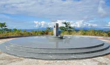
Indochina junction
The Indochina junction is not only famous during the resistance war against the US, but today this place is becoming very attractive to tourists on their journey to visit Kon Tum - the northernmost tip of the Central Highlands of Vietnam. The place of the Indochina junction on the majestic Truong Son range has always been in the memories of soldiers and young volunteers on their way to the Southern battlefield, battlefield C (Laos), battlefield K (Cambodia) over the years. Unforgettable war. This is the land known as the rooster crowing that all three countries hear together. Now this land is becoming one of the attractive tourist destinations for domestic and foreign tourists. Where places have gone down in history such as the Indochina junction (where Truong Son West road meets Truong Son East road during the resistance war), historical relics of the victory of Dak To - Tan Canh in April 1972; The border marker was jointly built by the three brother countries Vietnam - Laos - Cambodia on a mountain top 1,000m above sea level, about 30km from Playku town. This milestone was constructed by Kon Tum province in December 2007 under the supervision of experts from three countries sharing a common border. Representatives of the three countries' Ministries of Foreign Affairs held a solemn inauguration ceremony on January 18, 2008. The special milestone weighs 900 kg, is made of triangular cylindrical marble, is 2 meters high, and on each side of the milestone facing each country is attached the national emblem, the year the milestone was installed and the country's name in red letters of the government. that country. This is the second milestone marking all three countries to be placed on Vietnamese soil. The first milestone is the unified construction of the three countries Vietnam - Laos - China in A Pa Chai (Dien Bien). From the border junction marker, visitors have the opportunity to see the panoramic view of the Indochina junction land. Also here, tourists who want to visit Laos and Cambodia can complete exit procedures at the Vietnam border station at Bo Y international border gate. Source: Kon Tum Tourism
Quang Ngai
5949 view
Rating : National monument

Chu Mom Ray National Park
Chu Mom Ray National Park is located in Sa Thay and Ngoc Hoi districts (Kon Tum province). Right next to Chu Mom Ray National Park is Cambodia's Virachey National Park and Laos' Southeast Ghong Conservation Area. The flora of Chu Mom Ray National Forest is rich and diverse in species and status. There are about 1,534 plant species here, including 113 rare species belonging to the orchid family, gymnosperms, dioecious species, cycads, cycads, bamboo pine, rosewood, rosewood... The fauna of Chu Mom Ray National Park records 718 species, including 115 species of mammals, 275 species of birds, 41 species of reptiles and amphibians, 108 species of freshwater fish, and 179 species of insects. Among them, there are 124 rare species listed in the Red Book of Vietnam and the world, typically: red-cheeked gibbons, Truong Son muntjacs, gaurs, Indochinese tigers, elephants, black bears, fire leopards..., false lizards. 4 new stripes, white-edged snake, daisy-fronted snake..., hornbill, peacock, earth eagle... This place once marked many fierce battles during the period of "cutting Truong Son to save the country". Some places in the forest still have traces of trenches, bomb craters... The total area of Chu Mom Ray special-use forest is about 54,583.59 hectares; production forest 1,665.64 hectares; buffer zone 188,749 hectares. Including Bo Y and Sa Loong communes (Ngoc Hoi district); Ro Koi, Sa Nhon, Sa Son, Mo Rai, Ya Xier, Sa Thay town (Sa Thay district. This is where ethnic minority communities live, notably the Gia Rai and Ro Mam people. The proud point of the National Park is that there are 114 species in the Vietnam and world red books. In particular, the grassland (Ja Book valley) is the largest in Vietnam (more than 9,000 hectares) and has attracted many important species of ungulates and carnivores such as Truong Son muntjac, wild buffalo, tiger, etc. gaur, bison, elephant, black bear, fire leopard... and hundreds of species of reptiles and amphibians. In addition, on high mountain peaks such as Ngoc Linh, Ngoc Tu Ba, Chu Mom Ray peak... are home to many species of primates and arboreal animals such as gibbons, langurs, and precious birds such as hornbills. , land eagle, peacock… This is one of 94 special-use forests in Vietnam, with the largest area of primary forest and containing rare genetic resources. In 2004, Chu Mom Ray National Park was recognized as an ASEAN Heritage by the Association of Southeast Asian Nations. Source: Vietnam National Tourism Administration
Quang Ngai
5733 view
Rating : National monument

Mang Den historical relics and landscapes
Mang Den eco-tourism area is located in Mang Den town, Kon Plong district, Kon Tum province. Mang Den is a cluster of enemy strongholds, located on Road 5 from Kon Tum to Quang Ngai, now Highway 24, about 55 km northeast of Kon Tum city. This is a cluster of enemy bases deep in our liberated area. Surrounding the base is a complex system of dense obstacles with 10 layers of barbed wire and 2 layers of fence. Alternating between the layers of fence are anti-infantry mines, anti-tank mines and a trough-shaped trench 4m wide, 2.5m deep, densely planted with spikes. Inside were hundreds of blockhouses made of reinforced concrete and earthen wood, with tunnels connecting the fortifications and three corners with three mother blockhouses made of solid reinforced concrete. In mid-1974, the Kon Tum Provincial Party Committee and the B3 Command advocated attacking and destroying enemy bases to expand the liberated area and create momentum for the temporarily occupied Kon Tum area. After a period of preparation, at exactly 5:30 a.m. on October 3, 1974, the Commander of the 28th Infantry Regiment, Division 10, Army Corps 3 ordered to open fire to attack the enemy headquarters. At 7:55 a.m., our firepower simultaneously hit all targets. After a short time of developing the attack, at 10:45 a.m. we completely took control of point M12. Faced with the attack power of the H16 and H29 forces, the main force of the 28th Infantry Regiment and a number of our technical troops, on October 12, 1974, the enemy's last stronghold was located deep in the settlement area. The project in the Northeast of Kon Tum was completely wiped out. With the Mang Den victory in October 1974, our troops destroyed the enemy's last stronghold deep in our liberated area, breaking the enemy's safe corridor in the north of Kon Tum town, causing enemy troops to in the Northern Central Highlands battlefield was under strong threat. This victory liberated thousands of people and a large area of land, which was a great encouragement to promote the revolutionary actions of the people, especially ethnic minorities; At the same time, consolidate and build strong local government and armed forces. On the verge of victory, the armed forces surrounded the district capital of Mang But, liberating all the people in the area. Along with the victories at Dak Pet and Mang But bases, the Mang Den victory contributed to expanding the liberated area to Kon Tum town, creating new position and strength for the Central Highlands campaign, paving the way to liberate Saigon. , successfully ending the historic Ho Chi Minh campaign, unifying the country. Mang Den historical and scenic area was recognized as a national historical and scenic site on April 13, 2002. Source: Kon Tum Tourism
Quang Ngai
8207 view
Rating : National monument